Ah, I see you've stumbled upon an intriguing story about China's Mars Lander detecting subsurface geometrical shapes. Let's dive into the details and explore this scientific first!
**China's Mars Lander Detects Subsurface Geometrical Shapes in Scientific First**
In a groundbreaking achievement, China's Mars Lander, named Zhurong, has made an astonishing discovery beneath the surface of the Red Planet. Equipped with a ground-penetrating radar system, Zhurong was able to peer beneath Mars' surface and unveil a fascinating revelation.
Researchers have recently unveiled the results from the scans of Zhurong's landing site in Utopia Planitia, which have revealed the presence of irregular polygonal wedges buried at a depth of approximately 35 meters. These polygonal shapes range in size from centimeters to tens of meters across.
The scientists speculate that these buried polygons may have formed billions of years ago due to freeze-thaw cycles on Mars. However, they also consider the possibility that these shapes could be volcanic in nature, originating from cooling lava flows.
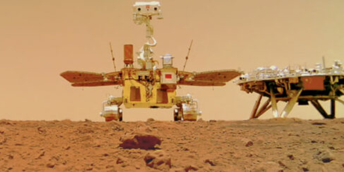
Zhurong, which landed on Mars on May 15, 2021, became the second rover ever to successfully touch down on the Red Planet, marking a significant milestone for China's space exploration endeavors. This adorable rover, named after a Chinese god of fire, diligently explored its landing site, captured mesmerizing pictures (including a selfie with its lander), conducted topographic studies, and carried out measurements using its ground-penetrating radar instrument.
Although Zhurong's primary mission was designed to last for three Earth months, it exceeded expectations and operated successfully for over a year before entering a planned hibernation period. Unfortunately, communication with the rover has been lost since May of 2022, leaving scientists eager to reestablish contact and continue its mission.
The researchers from the Institute of Geology and Geophysics under the Chinese Academy of Sciences, who worked with Zhurong's data, emphasize the significance of the rover's ground-penetrating radar (GPR) in complementing orbital radar explorations conducted by other missions such as ESA's Mars Express and China's Tianwen-1 orbiter. They believe that the in-situ GPR surveying performed by Zhurong provides crucial local details about shallow structures and composition within approximately 100-meter depths along the rover's traverse.
Utopia Planitia, where Zhurong explored, is a vast plain located within Utopia, the largest recognized impact basin on Mars and in the entire Solar System, with an estimated diameter of 3,300 kilometers. During its operational lifetime, Zhurong traveled a total distance of 1,921 meters, unveiling fascinating insights about this region.
The team led by Lei Zhang, in their paper published in Nature, shares that Zhurong's radar detected sixteen polygonal wedges within a distance of about 1.2 kilometers. This suggests that similar terrain with polygonal features is widely distributed beneath the surface of Utopia Planitia.
The researchers speculate that these polygonal features likely formed between 3.7 and 2.9 billion years ago during the Late Hesperian–Early Amazonian epochs on Mars. They propose that the buried palaeo-polygonal terrain, whether eroded or not, was subsequently covered by deposition of other materials during the Amazonian period.
While polygonal terrain has been observed in several areas of Mars in previous missions, this is the first time that indications of buried polygon features have been detected. The researchers explain that the formation of such buried polygonal terrain requires a cold environment, which might be associated with water/ice freeze-thaw processes in southern Utopia Planitia during early Mars' history.
According to the research, the possible presence of water and ice necessary for the freeze-thaw process in the wedges could have originated from cryogenic suction-induced moisture migration from an underground aquifer on Mars, snowfall from the air, or vapor diffusion for pore ice deposition.
Earlier radar data from Zhurong indicated the existence of multiple floods during the same time frame, which led to the creation of several layers beneath the surface of Utopia Planitia. The researchers propose that the most likely formation mechanisms for the polygonal features are soil contraction from wet sediments that dried, resulting in mud-cracks. However, they acknowledge that contraction from cooling lava could have also contributed to thermal contraction cracking.
In any case, the researchers highlight that the presence of these polygons signifies a significant change in Mars' climate, contributing to the understanding of the planet's geological history. The contrast between the layers above and below the 35-meter depth indicates a notable transformation in water activity or thermal conditions during ancient Martian times, suggesting a climatic upheaval at low-to-mid latitudes.
This fascinating discovery by China's Mars Lander, Zhurong, showcases the ongoing efforts and advancements in planetary exploration. It adds valuable insights to our understanding of Mars' geological past and the potential for habitability. As scientists continue to analyze the data and explore{finish}
**FAQs**
1. **Could these subsurface geometrical shapes on Mars indicate the presence of ancient life?**
While the discovery of subsurface geometrical shapes is intriguing, it does not directly indicate the presence of ancient life. These shapes are believed to have formed due to geological processes such as freeze-thaw cycles or volcanic activity. However, the presence of such geological features provides valuable information about Mars' past climate and the potential for habitability.
2. **Why is the detection of buried polygonal terrain significant?**
The detection of buried polygonal terrain is significant because it sheds light on Mars' geological history and climate. The formation of these polygons suggests a change in water activity or thermal conditions during ancient times. By studying these features, scientists can gain a better understanding of the planet's past and its potential for supporting life.
3. **What are the future implications of this discovery?**
This discovery has important implications for future Mars missions and exploration. The presence of subsurface geometrical shapes indicates the potential for interesting geological formations and processes beneath the Martian surface. It highlights the need for further investigation to uncover more secrets about Mars' history and the possibility of habitable environments. Future rovers and landers can build upon this knowledge to deepen our understanding of the Red Planet.